

Accelerating 5G Rollout
- Carrier routes overlay to help in locating sites closer to fiber in a search ring
- Online Lit datasets overlay to help identify which sites in a search ring host fiber
- Overlay of licensed Microwave (MW) or registered Millimeters links in regulator’s database to help identifying existing LOS between sites in a search ring
- Height assessment of structures via a real cities 3D map, such as windows 10 Bing Maps App.
Would an application with these features be valuable for the RF team? Well, let start with the carrier fiber routes. One could object that, on one hand, not all carriers have their fiber footprints available for free download and that, on the other hand, commercial datasets are expensive. Worse, the free download from carrier websites are in KMZ or KML format, which can be extremely slow to navigate with Google Earth because of the large number of polylines displayed. This could be a criterion of the tool selection.
The RF supporting application for the backhaul availability pre-check must be capable of extracting the KMZ/KML data and parsing it into a relational database. The lateral distance from a site to the fiber footprint would be a metric for the site candidate selection. The tool should support other file formats such as ESRI Shapefile, generally provided by commercial fiber routes dataset vendors. Due to their low cost, an affordable alternative could be the usage of the Lit fiber dataset.
In general, Lit fiber datasets include all carriers nationwide. They offer the advantage of exactly pinpointing on a map the locations with fiber connection in service. In addition, they do not consume resources as heavily during display. When displayed, the following data attributes are provided: carrier name, fiber supplier name, On Net or Near Net, latitude and longitude, location address and datacenter. This information is very valuable in the sense that the RF engineer can now select 5G sites with the objective of minimizing carriers’ network outage impact. It aids in diversifying the fiber suppliers inside a coverage cluster.
In geographic areas where neither fiber routes nor the Lit fiber dataset is available, overlaying frequencies with regulators’ registered links could still be helpful in site candidate decisions. Rather than being about line of sight verification, this idea is about having a visual representation of existing links from licensees in an area of interest. Of course, some licensed or registered links could be no longer in operation because of new obstacles caused by new building construction, for example. Nevertheless, RF engineering can still locate which structure likely hosts a cellular base station. This information could be passed along with the selected site candidates to the development team.
Terrain elevation, surrounding clusters and structure height are critical pieces of information when designing cellular networks. The tool to be used for the backhaul availability pre-check would be a good asset if it offers functionalities for structural height assessment. Instead of reliance on costly commercial 3D cities datasets, the usage of free 3D maps such as Bing Maps App is preferable.
The table below shows a sample of information that RF engineers would supply in the workflow process. Engineers should also include other good candidates on coverage perspective without existing backhaul for sites so that the development team can make objective cost analyses during the decision.
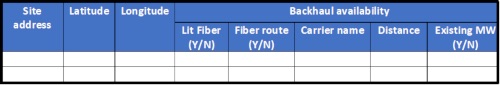
Figure 2 - RF Engineer Table
Backhaul design completion phase
At this step of the adapted workflow process, the percentage of site candidates designated as stranded should be far less than using the traditional process. It’s important to remember that 5G technology operates in the lower sub-band 6 GHz, very